App screenshots




About the app
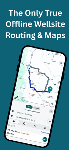
Find the LSD, then drive to it. Routes calculate on your phone if offline, on a server if online. Oilfield Route is a well search and GPS navigation app for oil and gas crews working the patch in Alberta, BC, Saskatchewan and Manitoba. Download your province once. After that, search wells and legal land, calculate a route, and follow turn-by-turn directions with the phone in airplane mode. You do not have to preload one exact route before you leave coverage. WHAT OFFLINE ACTUALLY MEANS HERE (With a PRO Subscription)
Read more
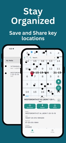
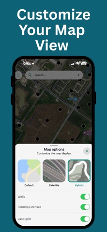
Offline here does not mean a cached well list, and it does not mean one route you had to plan before you left. Oilfield Route calculates the route on the device. - Search wells and legal land offline - Calculate a brand-new route offline - Reroute after a missed turn, offline - Full turn-by-turn guidance, offline - Works with the phone in airplane mode FIND THE WELL, THE LEASE OR THE LSD - Search by UWI, well name or Operator - Locate DLS and LSD legal land descriptions - Locate NTS map sheet locations - Operator, depth, drill date, licence and other well details - Toggle wells, permits and land grid layers on the map - Save wells and locations into organized groups - Share a location or a whole group with your crew ROUTING FOR FIELD VEHICLES - Car, light-truck and heavy-truck route profiles - Multi-stop route planning and optimization - Navigate to the wellsite or DLS coordinates, not a street address - Highways, grid roads and lease roads - Street, satellite and hybrid map views FILTER BY WELL STATUS, INCLUDING ORPHANED WELLS Find orphaned wells and focus your map on the sites relevant to your work. Filter by Orphaned, Active, Abandoned, and other available statuses to reduce map clutter and help plan field visits, inspections, and reclamation work. PLANS Essential - online well and land search, well data, location sharing, crew groups, online turn-by-turn navigation. Pro - everything in Essential, plus downloadable offline maps, offline route calculation, offline turn-by-turn, and vehicle-optimized routing. COVERAGE Alberta, British Columbia, Saskatchewan and Manitoba, with downloadable regional maps built for low-signal travel. Crews who work both sides of the border also get 17 US states. A subscription is required for mapping, well search and navigation. Always confirm site access, road conditions and safety requirements on the ground - this app assists navigation, it does not replace field judgment. Built by GeoActivity, 15+ years in oil and gas software. Terms of Use: https://oilfieldroute.com/terms.html Privacy Policy: https://oilfieldroute.com/privacy.html
- Developer
- D'GIS Group Ltd.
- Category
- Navigation
- Age rating
- 4+
- Available on
- iPhone and Android
About the program
We deliver geospatial technology solutions, and field navigation tools for oil field workers. Traditional consumer mapping systems are not designed for lease roads, remote access points, or wellsite navigation tools. D'GIS Group focuses exclusively on building spatial intelligence systems and geospatial technology solutions tailored for real-world oilfield conditions. We provide energy professionals with reliable, accurate, and field-ready geospatial data, and support that improve safety, efficiency, and operational awareness.
What to post
Post ideas, not real affiliate posts
- Post idea
Testing True Offline Routing in the Patch
Put your phone into airplane mode on a remote grid road, enter an LSD coordinate, and show how the app instantly calculates full turn-by-turn navigation without any cellular signal.
- Post idea
Heavy Truck Routing to Multiple Well Sites
Show how standard GPS maps fail on lease roads, then demonstrate selecting the heavy-truck profile in the app to route through three wellsites using grid roads and LSD coordinates.
- Post idea
Filtering Orphaned Wells for Field Inspections
Film your tablet or phone screen toggling the status filter to show only orphaned wells in Alberta, saving the sites into a crew folder to plan an inspection day.
How it works
- 1
Share your link or code
Put it in your bio, videos or stories.
- 2
Earn on each sale
Get commission when someone you referred subscribes or buys.
- 3
Get paid
Track every referral in your dashboard and get paid out.
Questions
- How much can I earn promoting Oilfield Route?
- You earn 40% of each referral's first purchase.
- When do I get paid?
- The company pays you directly. Paid at least every 4 months once you pass the minimum.
- How are my referrals tracked?
- You get your own link and short code. Anyone who taps your link or enters your code before their first purchase is linked to you, and their renewals keep counting.
- Does it cost anything to join?
- No. Joining is free for affiliates.
Earnings example
EstimateEstimated from this app's App Store prices and the industry average split between plans (RevenueCat State of Subscription Apps 2026). Not this app's own sales. An example, not a promise.
How you get paid
- The company pays you directly
- Paid at least every 4 months once you pass the minimum
What you share
Your own link and a short code. Followers tap the link, or enter the code in the app before they buy.
I want to help you setup your iOS or android affiliate scheme
Book a call with me and we can run through your ideas, get help with setup, or speak to me about your current affiliate situation
“I couldn't use affiliate marketing in my subscription app, so I built insert affiliate to solve this issue”- Michael Butler, CEO